using NDR appears to be a conservative
approach As a result of applying
the dynamic resistance factor (jdyn) to
calculate the NDR (see equation 1 in
Section 3.0), two load factors are virtually
applied to MFSLSL, which seems
to be an overly conservative approach,
especially when the bearing materials are
very hard such as PWR and rock. Also, the
AASHTO approach for the determination
of jdyn (Table 10.5.5.2.3-1) is believed to
be inadequate; NDR should probably be
evaluated for various soil layers using
the theories of soil dynamics and not just
using the conditions included in AASHTO
Table 10.5.5.2.3-1. In addition, if the NDR
is stipulated not greater than the MFSR as
specified by some DOTs, larger pile sizes
are required. In the bidding or design
phase when no PDA data is available, this
approach appears to result in larger pile
sizes than what is necessary if the bearing
materials are anticipated to be hard
PWR. Based on PDA test results, the geotechnical
axial capacity of a pile founded
in PWR can in fact exceed the MFSR,
which was demonstrated by test results
discussed in Section 5. Accordingly,
estimating the pile sizes that would be
founded in hard PWR during the design
or bidding phase using MFSR seems to be
a practical approach.
2. Local geology and subsurface
conditions at test locations
According to USGS geologic maps, the
project site is located within the Powers
Ferry Formation, Chattahoochee Palisades
and Factory Shoals Formation of the
Sandy Springs Group of the Piedmont
Physiographic Province of Georgia.
Piedmont residuum is a source of foundation
bearing soils for several major cities
in the eastern United States, including
Atlanta, Columbia, S.C., Charlotte, N.C.,
Raleigh, N.C., Wilmington, Del., Baltimore,
Md. and Richmond, Va. (Mayne et. al,
2000). The name Piedmont means “foot of
the mountains,” reflecting a highly weathered
geomorphological state under rolling
terrains since it bears the remnants
of what were mountains. The original
Paleozoic rocks were primarily of metamorphic
and igneous origin, including
predominantly schist, gneiss and granite
although localized regions contain slate,
phyllite, greenstone and diabase. The rocks
of the Piedmont have been decomposed
mechanically and chemically, resulting
in residuum and saprolites. These rocks
are composed of crystalline structures
(Thompson et al., 2012).
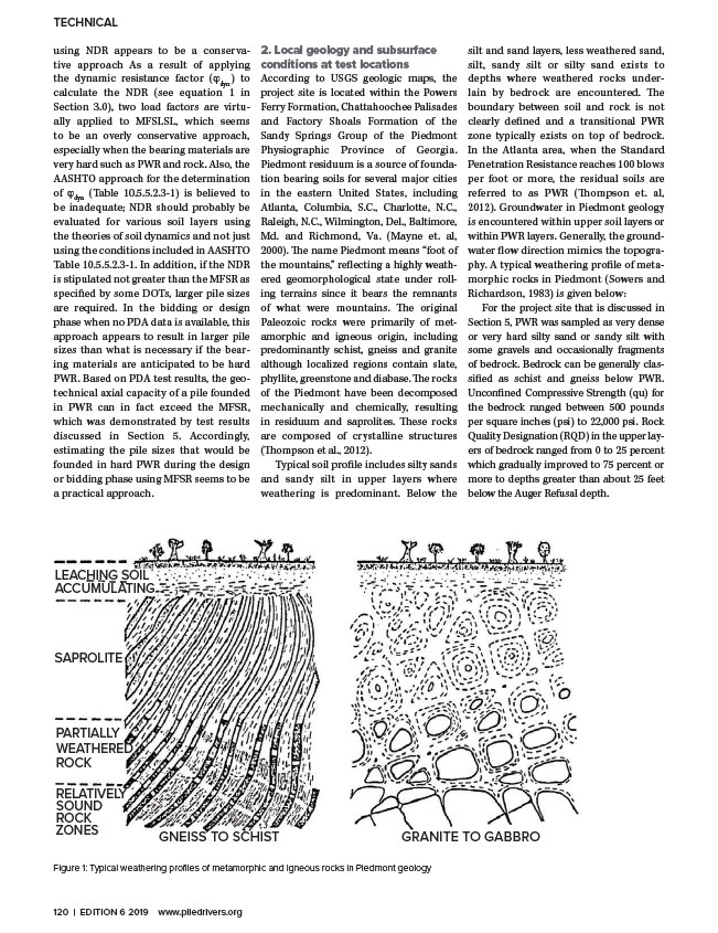
Typical soil profile includes silty sands
and sandy silt in upper layers where
weathering is predominant. Below the
TECHNICAL
LEACHING SOIL
ACCUMULATING
SAPROLITE
GNEISS TO SCHIST GRANITE TO GABBRO
PARTIALLY
WEATHERED
ROCK
RELATIVELY
SOUND
ROCK
ZONES
Figure 1: Typical weathering profiles of metamorphic and igneous rocks in Piedmont geology
silt and sand layers, less weathered sand,
silt, sandy silt or silty sand exists to
depths where weathered rocks underlain
by bedrock are encountered. The
boundary between soil and rock is not
clearly defined and a transitional PWR
zone typically exists on top of bedrock.
In the Atlanta area, when the Standard
Penetration Resistance reaches 100 blows
per foot or more, the residual soils are
referred to as PWR (Thompson et. al,
2012). Groundwater in Piedmont geology
is encountered within upper soil layers or
within PWR layers. Generally, the groundwater
flow direction mimics the topography.
A typical weathering profile of metamorphic
rocks in Piedmont (Sowers and
Richardson, 1983) is given below:
For the project site that is discussed in
Section 5, PWR was sampled as very dense
or very hard silty sand or sandy silt with
some gravels and occasionally fragments
of bedrock. Bedrock can be generally classified
as schist and gneiss below PWR.
Unconfined Compressive Strength (qu) for
the bedrock ranged between 500 pounds
per square inches (psi) to 22,000 psi. Rock
Quality Designation (RQD) in the upper layers
of bedrock ranged from 0 to 25 percent
which gradually improved to 75 percent or
more to depths greater than about 25 feet
below the Auger Refusal depth.
120 | EDITION 6 2019 www.piledrivers.org
/www.piledrivers.org