with a software package that bundles the
more traditional sources: weather satel-lites,
NEXRAD, surface observations, rain
gauges, river gauges, and other input, much
of which was knocked out by the hurricane.
Rodriguez’s team is primarily using
OPC precipitation and storm height
estimates generated every five minutes.
The NWS says it expects the San Juan
NEXRAD weather radar system to be
back in service by the end of January 2018.
During both Hurricanes Irma and
Maria, FEMA officials in the National
Response Coordination Center and
regional offices also used OPC to gain an
awareness of offshore precipitation and
weather system movements.
“Instead of being forced to wait for the
storm to come into view of ground-based
radar for indications of storm intensity,
emergency managers were able to receive
an early look from OPC and maximize
situation awareness,” said Department of
Homeland Security (DHS) Science and
Technology Program Manager Darren
P. Wilson. DHS, the parent organiza-tion
of FEMA, would like to make the
OPC available through its next-genera-tion
hurricane evacuation system, called
HURREVAC-eXtended, set to be rolled
out next year, says Wilson.
The US Air Force has also taken a
keen interest in the program after MITLL
provided an OPC demonstration last win-ter.
Veillette says the Air Force is planning
to provide funding to develop a global
version of the tool as well as the 12-hour
forecast capability, an enhancement that
will also be available to the FAA and
other users.
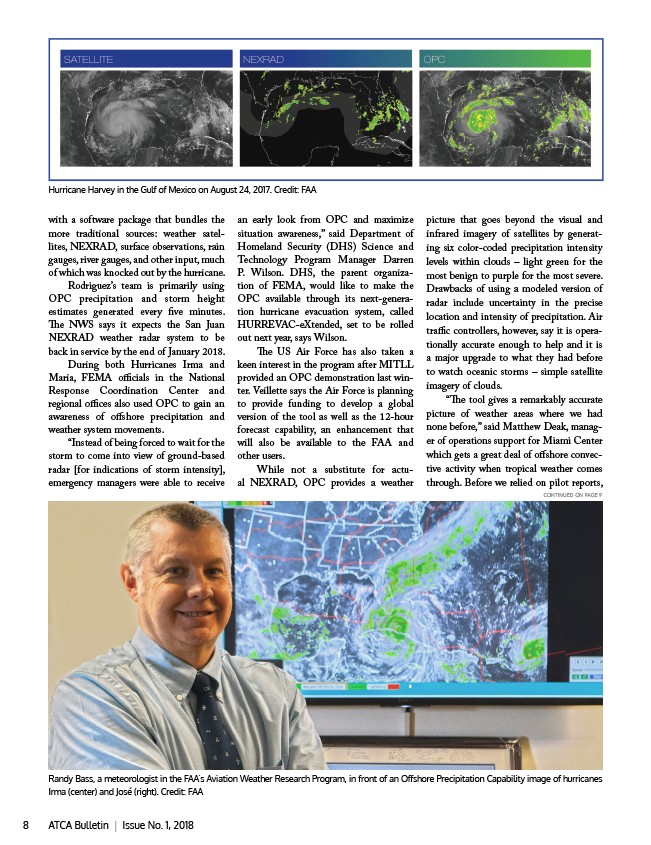
While not a substitute for actu-al
NEXRAD, OPC provides a weather
picture that goes beyond the visual and
infrared imagery of satellites by generat-ing
six color-coded precipitation intensity
levels within clouds – light green for the
most benign to purple for the most severe.
Drawbacks of using a modeled version of
radar include uncertainty in the precise
location and intensity of precipitation. Air
traffic controllers, however, say it is opera-tionally
accurate enough to help and it is
a major upgrade to what they had before
to watch oceanic storms – simple satellite
imagery of clouds.
“The tool gives a remarkably accurate
picture of weather areas where we had
none before,” said Matthew Deak, manag-er
of operations support for Miami Center
which gets a great deal of offshore convec-tive
activity when tropical weather comes
through. Before we relied on pilot reports,
Hurricane Harvey in the Gulf of Mexico on August 24, 2017. Credit: FAA
CONTINUED ON PAGE 9
Randy Bass, a meteorologist in the FAA’s Aviation Weather Research Program, in front of an Offshore Precipitation Capability image of hurricanes
Irma (center) and José (right). Credit: FAA
8 ATCA Bulletin | Issue No. 1, 2018